|
 |
Communications and Navigation Technology aboard VALIS
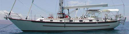
Aboard VALIS we have several different ways to communicate with the outside world. I'm going to describe what we have, how it is all connected, how we use it, and where we got it. What we've done is not necessarily the best way, but it does work for us.
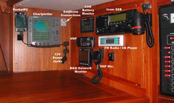
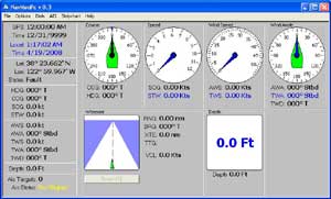
VALIS Navstation (circa 2006)
Voice Communication
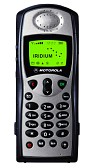
For talking with people back on land, we generally use the Iridium Satellite Phone (not shown in the navstation photo). Ours is a Motorola model 9505, but the version available now will be the 9505A. The satphone comes with an detachable antenna for handheld operations, and this works reasonably well when in the cockpit. More often, we use an external antenna mounted on the stern rail, connected via coax cable to a jack at the navstation. There is an adaptor for the satphone that provides a jack for connection to the external antenna, and we use a short (about four feet) coax jumper to connect the phone to the navstation jack. The satphone and antenna use "TNC" connectors, and I use the more common "BNC" style jumper cable with BNC-to-TNC adaptors. At the navstation we have several 12V "cigarette lighter" power jacks, and these are used to charge the satphone battery (we usually keep the charger connected -- it draws under 0.1A)
Note that there are several different satellite communications systems out there, and they have differing coverage areas, costs, and company financial health. I chose Iridium because it provides true global coverage, competetive rates, and a good chance that the service will remain available.
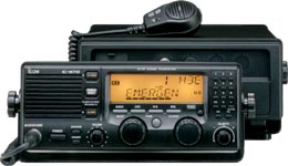
Communications with other vessels will either be via the VHF (for short-range work), or via the SSB radio (for over-the-horizon communications). Our VHF transceiver is mounted at the navstation, with a remote microphone in the cockpit. The VHF antenna is a masthead whip. The SSB is an Icom IC-M710RT, which has a small control head mounted at the navstation, and the main radio electronics mounted in a locker in the salon. The SSB feeds an Icom AT120 automatic antenna tuner, installed in a stern locker. The antenna tuner drives the backstay, which is insulated at top and bottom. The remote-head Icom IC-M710RT is no longer manufactured, but the one-piece IC-M170 is still available.
Data Communications Hardware
For data communications (email), we use either the satphone, or the SSB and a Pactor modem. Lately, the Satphone has been our principal email gateway. For data operation, the satphone requires that a "Data Adaptor" be clipped onto the bottom of the phone (and the 12V charger adaptor stacks onto the bottom of that). The data adaptor has a DB9 serial jack which connects to the PC RS232 interface via a cable. This turns into a pretty messy arrangement, with the antenna, power, and data cables all running to and from the phone. I use small-diameter antenna and data cables, and try to keep them bundled neatly, and the result isn't nearly as bad as it sounds.
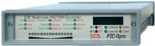
As a backup to the satphone, I use the SSB, in conjunction with the SCS PTC-IIpro Pactor Modem. The PTC-II connects to the main SSB unit with several data and control cables, and to the PC RS232 interface with a serial cable. In this configuration, the PTC-II is powered from the SSB. The NMEA GPS data can be connected directly to the PTC-II, which will then make this GPS data available to the PC, but I have elected to connect my NMEA data to the PC instead, via an RS232 connection. The PTC-II can control the frequency of the Icom SSB, and this is a real convenience.
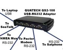
You may have wondered how I get all of these serial cables into the PC (a laptop), since many modern laptops don't even have one serial port. For these connections, I am using a 4-port RS232-to-USB adaptor from QuaTech. From time to time I have used multiple RS232/USB adaptor "dongles", and these have worked fine for me, but having the quad adaptor installed behind the navstation panel heeps the wiring simple (and the port numbers consistent). The adaptor is powered from the laptop through the USB cable. The navstation photo above does not show the USB jack which was since mounted on the panel.
Data Communications Software
Using the Iridium satphone,
even for voice, requires a contract with a service provider. You can
set
up
a regularly-billed service (much like landline phone service), but
like most people I have instead elected to purchase pre-paid "blocks"
of minutes. I have been purchasing 500 minute blocks, and the
rate is about $1.50 per minute. You can purchase smaller blocks, but
the per-minute rate is higher, and the minutes are only valid for a
limited time (from one to six months) The 500-minute blocks are valid
for one year, and will "roll over" if you purchase another 500-min
block
within
the year. The smaller blocks will not roll over. For short-term use,
it may be better to rent a satphone.
Now we've got voice, but for data you still need an ISP contract. Sailmail now offers this service as part of the regular Sailmail SSB account. I use the company "Global Marine Networks" (GMN) and their "XGate" system. When I was originally setting all this up, there were fewer options for Iridium data service, and GMN had perhaps the most robust and efficient service. Satphone connections will drop from time to time, and if the connection protocol does not allow for this, it is nearly impossible to complete a significant data connection. The GMN software will seamlessy resume a dropped connection in mid-stream. SailMail, and no doubt other services, now provide this capability, but I remain satisfied with GMN. A 12-month subscription to XGate currently runs $240, with a one-time $59 software/setup fee.
Note that GMN has services available that will provide weather data over the satphone link. These look quite attractive, but the rules of the Pacific Cup, and my desire to "do it myself" have led to our current weather-forecast solution (see below).
For SSB email, I use "SailMail", a private radio service that operates on the marine bands. SailMail is a non-profit organization, started and run my sailors, and has network base-stations throughout the world. The annual dues are currently $250. Sailmail does not charge per-minute, but there is a weekly time-limit of 90 minutes. This is more than sufficient for typical email, but will not support large file downloads or uploads. Using the PTC-II modem, the SSB datarate is as much as 2700 bits per second (under perfect conditions), and this will degrade to less than 100 Bit/sec as the conditions worsen (sometimes much less).
Amateur Radio operators can use the free "Winlink' Ham service, instead of (or in addition to) SailMail. The usual ham radio non-commercial use restrictions apply. There are no time limits on Winlink (other than courtesy to other hams trying to share the network). The Winlink base stations are more numerous than SailMail's, but perhaps less stable. The Airmail program can be configured to work with both SailMail and Winlink.
The email software we use with SailMail is "Airmail", along with "GetFax" and "Viewfax". These are written by Jim Corenman, one of the SailMail founders, and are available for free. A very useful radio-propagation prediction tool is also available, and all of these integrate well with AirMail. Getfax/Viewfax will also work with the PTC-II modem to receive SSB weatherfax transmissions, as well as Navtex and RTTY text transmissions.
Getting Our Weather Data
Before we began using the satphone for email, we received weatherfaxes from the scheduled SSB broadcasts. Usually we tuned to the Coast Guard's Pt. Reyes station "NMC", but as we approached Hawaii the Honolulu station "KVM70" would occasionally be more easily received. The WFAX broadcasts are sent several times a day on several frequencies. and depending on your location (and sunspots, etc), different frequencies and times will work better than others. The Getfax program will read a textfile (which you can edit) that will cause the SSB receiver to tune to the desired frequency at a specified time, and begin receiving a given WFAX or bulletin. With this automatic receiving function there is little need to stand by the radio/computer. Just turn everything on and let Getfax run. Viewfax will display the weatherfaxes.after they have been received.
In addition to the WFAX charts, we receive "GRIB" (GRIdded Binary) files. These are compact datasets that typically contain surface pressure and windspeed information for a user-selected area. The Grib file can contain data and predictions for several days out, and they are highly configurable. Gribfiles are available from several sources, and we get ours from "Saildocs", a service of SailMail. Our typical gribfile is about 10KBytes in size, and they are delivered via email -- for us either SailMail or satphone email. Saildocs will email these gribfiles to any email account -- not just SailMail accounts, and will do it for free. See the Saildocs website for more information. You do not have to be a SailMail member in order to use Saildocs.
Since we have been using satphone email, we have stopped directly receiving the WFAX broadcasts, and instead receive the WFAX graphics files sent to us by email. Each file is around 30KBytes, and we typically receive four of them: the current Surface conditions, the 24 and 48-hour surface predictions, and the 24-hour wind/wave forecast. Receiving these files through SailMail would exceed our time limit, but with the Iridium email it takes about ten minutes for these plus the gribfile to be received.
There are no doubt other ways to have the WFAX charts emailed, but what I have done is to write a simple "cron" program that runs on our shoreside ISP server. This task executes daily, at which time it downloads the desired WFAX images from the NOAA website, and emails them to our Iridium email account. We get this data once a day, but it is certainly possible to get several updates in a 24-hour period. When we're not out sailing, the cron program also emails these wfax files to my home email account.
Position Reporting
This is a rapidly evolving area, but on VALIS we report in several ways. First, we (usually) send daily email to Pangolin's "Yotreps", a free position-reporting service. Anyone interested can visit the Yotreps website and see our position and track. The VALIS website has a link to our Yotreps position report. The Pangolin website has many other interesting tools and services available, and is well worth a visit.
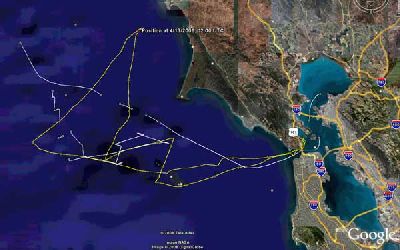
We also save a daily logfile that is taken from our navigation equipment NMEA datastream. We usually take the data for the previous 24-hours and post-process it with a homebrew program that creates GoogleEarth "KMZ" files. We sent these KMZ files to the VALIS blog, along with our daily report, and those interested can use the KMZ file to view our daily track (including other interesting information) on Google Earth.
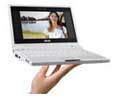
In the navstation photo, the PocketPC is used to capture and display the navsystem NMEA data, using home-brew software and a bluetooth link to the NMEA multiplexer. More recently the PocketPC has been replaced by a small, low-power, low-cost laptop; the EeePC. The EeePc consumes about 2 Amps at 12V, and will be left running continuously.
AIS
AIS (Automatic Identification System) is a relatively new technology, and it is a big deal. For the last several years, all large commercial vessels have been required to carry an AIS transponder, which regularly broadcasts information about the vessel's course, speed, rate-of-turn, ship name, callsign, and a whole lot more. Other boats (such as VALIS) can install an AIS receiver, or a full transponder if desired, and with this equipment monitor the nearby AIS-equipped vessels. By monitoring these AIS signals we can identify potential collisions or near-misses, and take appropriate action.
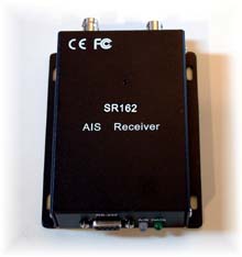
VALIS has an AIS receive-only unit: the SR-162. The receiver is connected to a short marine VHF whip antenna mounted on the stern rail. With this configuration we receive AIS signals at a range of 15 miles or more. The receiver puts out a NMEA datastream, which is connected to our NMEA multiplexer. Homebrew software interprets this (and all other) NMEA data, and then plots the positions of the local AIS-equipped ships. This software also calculates CPA (Closest Point of Approach) and TCPA (Time of the CPA), and will sound an alarm should a threatening target enter a specified guardzone. Many modern chartplotters will work with AIS data, and with our upcoming navsystem upgrade we should have this capability as well.
Obligatory disclaimer: Not all vessels transmit AIS signals. A prudent mariner will use all available information, including, but not limited to, AIS, RADAR, eyes, ears, etc, as available. It is perfectly possible to sail safely without having AIS capability, and merely installing AIS capability will not automatically make you a better sailor. It could make you a worse sailor, if you concentrate on AIS and disregard your other information sources. By the way, you can say the same thing about radar.
Navsystems and Power Consumption
On VALIS we typically do two types of sailing: daysailing, and extended passages. When daysailing in the San Francisco Bay and environs we are not particularly concerned about power consumption. We have a big battery bank, we run the engine to enter and leave the marina (at least), and when not sailing the solar panels on VALIS keeps the batteries charged. When daysailing we typically have both the navstation and the helm chartplotters powered-up.
During long passages, such as the two-week Pacific Cup race to Hawaii, or the three-week return to Sausalito, we are very conscious of our power consumption. We use the engine very little -- if racing, not at all except for battery-charging. In the past, we have continuously run the navstation chartplotter, the GPS, and the B&G wind/speed/depth displays. Occasionally we use the power-hungry hydraulic autopilot. We sail through the night, and keep the tricolor illuminated during the dark hours. Our solar panels will not keep up with these loads, and we must run the engine about one hour per day to replenish the batteries.
It is usually easier to reduce power consumption than to increase the power source output. I like to run the engine as little as possible, since it is noisy, generates heat, and burns fuel. We have taken some steps to reduce consumption, such as replacing the power-hungry incandescant bulb in the top-of-the-mast tricolor with low-power LEDs. Interior lights are low-power units wherever possible.We run the helm chartplotter as little as necessary. When radar is called for, we usually run it in timed/standby mode.
When trying to reduce power consumption, the highest-consuming items are the best candidates for optimization. At this point, the navstation chartplotter is probably the next place to start looking. In the middle of the ocean, there is little need to view charts on the chartplotter. The chartplotter does provide a good indication of course and speed, and serves as a below-deck master display of all nav-data. The chartplotter is part of the integrated radar system, and will be able to display and monitor AIS traffic.
In our new navsystem, all of these at-sea chartplotter functions except radar will be performed by the EeePC, with a significantly lower power consumption. I have been adding and fine-tuning the features of the homebrew program, trying to make as useful as possible, and with an absolute minimum of unnecessary bells and whistles. If this comes together as I plan, it will have a significant impact on our daily power budget.
When radar is necessary, or when making landfall, the chartplotters will be turned back on. But while at sea I hope to keep their use to a minimum.
Iridium Satphone
|
External Satphone Antenna 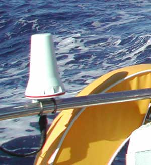 |
Satphone "Data Adaptor" 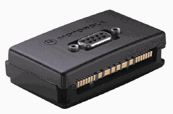 |
Icom 710RT
|
XGate, from Global Marine Networks |
|
SCS PTC-IIpro Pactor Modem |
QuaTech
USB-Serial Adaptor |
|
HF Radio Weatherfax Transmission Schedules Pt. Reyes: http://weather.noaa.gov/pub/fax/hfreyes.txt Honolulu: http://weather.noaa.gov/pub/fax/hfhi.txt |
Weatherfax Charts
on the Net |
|
ShipModul
NMEA Multiplexers |
SR162 AIS Receiver |
Asus EeePC |